send link to app

Pilot Atlas app for iPhone and iPad


4.6 ( 2976 ratings )
Reference Navigation
Developer: HiRo Applications
7.99 USD
Current version: 3.7, last update: 3 years ago
First release : 18 Oct 2012
App size: 580.81 Mb

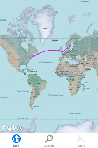
Pilot Atlas is a complete offline pilot map of the world with almost 45 000 airports and over 120 000 Navpoints works with both your iPad and your iPhone! Find exactly where you are in relation to any VOR or Fix.
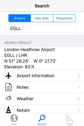
Database also includes useful information about the airports and the navaids.
Geographical points includes major cities, lakes, rivers and much more.

The graticules are based on WGS84 so you can use your current location from any GPS to find where you are on the map or just type in the closest waypoint in the search bar.
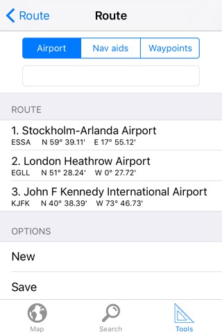
You can draw and save your own routes and see exactly what you are flying over.

Features included are:
•Runway information
•Frequency lists
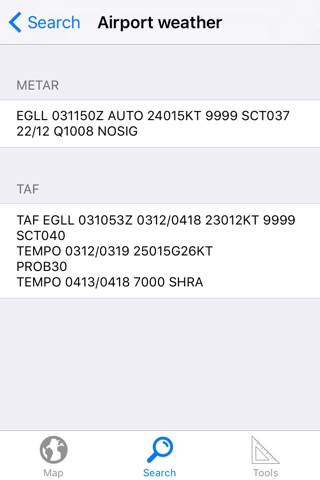
•Download weather for any airport
•Frequencies and idents for Nav aids
•Create and save your own routes.
•Draw a Great Circle lines to find the closes path between two airports.
•Range Rings
•Easy to use converter – Perfect for PAs
•Crosswind calculator
•Temperature Correction table
•Weather brief – Create your own briefing folder with your airports and have save the weather for offline use
•Add Custom waypoints.
•GPS functionality
•Save your favorite airports
•Save notes for any airport
•Quick Search

It was created by pilots for pilots. If you wish us to add any features please let us know and we will try to add it during the upcoming updates
This is truly a must have in your flightbag!

Pros and cons of Pilot Atlas app for iPhone and iPad

Pilot Atlas app good for

Awesome atlas for the professional aviator, I fly the 767 at Air Canada and the app is open all the time in the air, very easy to read and to plan your actual flight plan on the atlas, and most important you can mark your FIR boundaries to follow the exits. 5 star app, with awesome technical support!!!!!!!!!, BTW, Im trying to get to word around Air Canada to get the app ;-)
Great app with great features, comparing the first version, great changes... But lack of waypoints, also "creating custom waypoints" is not working for the moment.

Some bad moments

VERY basic app which provides very little useful information above and beyond whats available on cheaper apps such as maps.me of national geographic. As a professional pilot I would recommend you spend your money elsewhere.
I too am an international airline pilot flying to all parts of the globe. This app does not work. Should also come with a tutorial. I would not want this if it were free. How do I get a refund? They should be paying us to use it.
I just bought this and am very disappointed. The atlas is very low resolution. For example, I live in Colorado and Pikes Peak does not appear on the map nor do any other mountains. As you zoom in on the map the details disappear and the print is so small you need a magnifying glass to read it. Save your money on this one. Not worth it.
It works good. Its missing some waypoints and not up to date, though. Being able to put multiple waypoints would be great.
Maybe "Pilot Atlas" means something else in other countries but in the US its always been similar to a road map (for cars) with the airways overlaid on it so you could identify what you saw on the ground or explain points of interest to your passengers. I even had one that listed all the a.m. radio stations locations. This map doesnt even show large lakes in my area or highways, etc so its basically useless, I already have my piloting crap, (nav screen in the cockpit) so I know where the VORs are, I need to relate to whats on the ground so there needs to be more detail like a typical hard copy old style paper Pilot Atlas book!
This app is a great bargain for twelve dollars. You can follow along using a GPS and it has a worldwide database. I use it in a commercial airliner and it has been great for situational awareness.